

Photo/ travelog: A Hebridean Odyssey part ll
Guest post by Rob Bruce

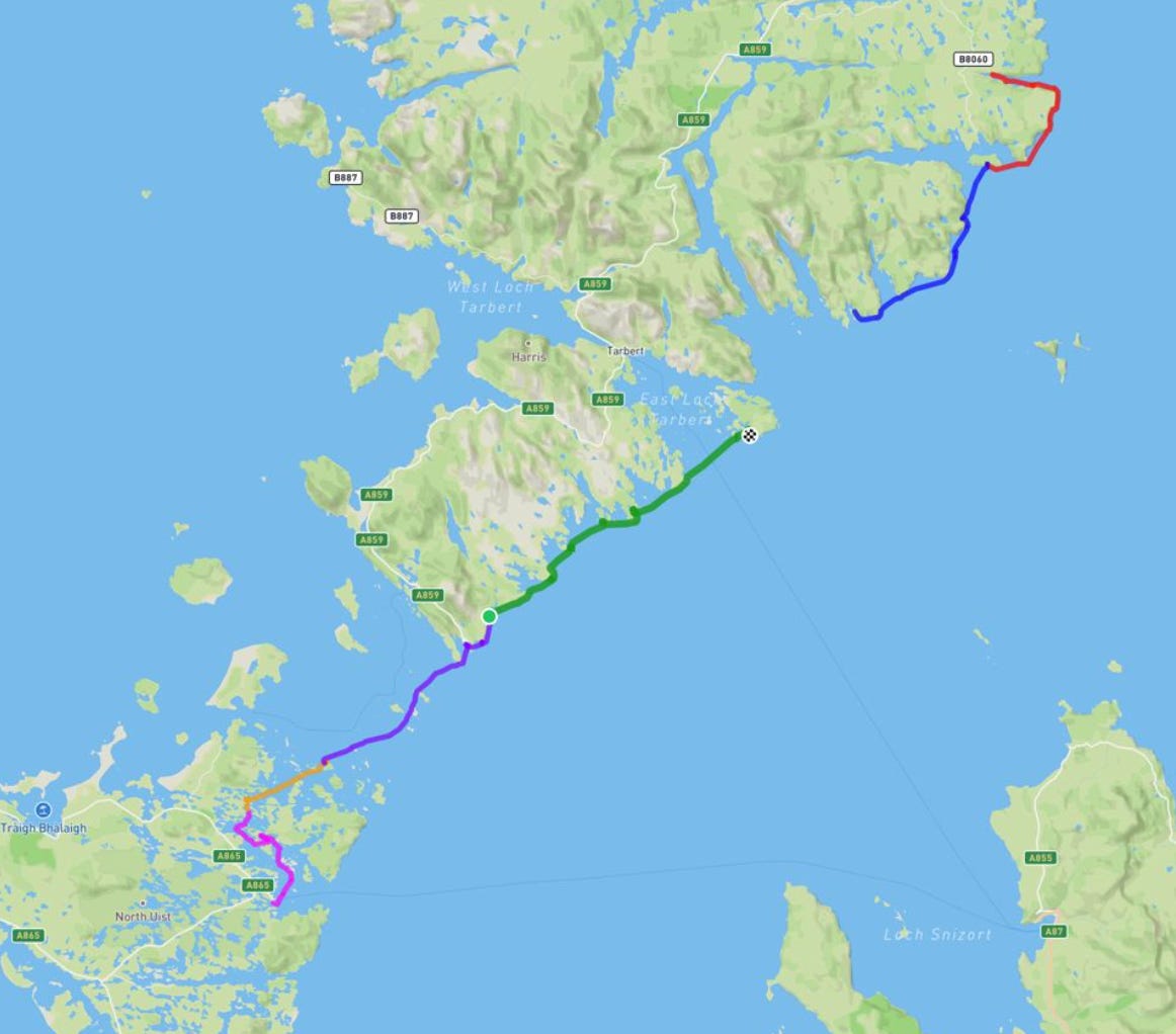
Last year, Rob and his friend Paul kayaked from Castlebay on Barra to Lochmaddy on North Uist (read about that here). This year they continued the journey, going from Lochmaddy almost to Stornoway over seven days in late May. Here, Rob recounts the journey - as told to Jackie Kemp.
Day One: The Riddle of the Sands

I had had to postpone the trip slightly due to a work event which, frustratingly, coincided with unusually settled weather in the Outer Hebrides. I knew we might be missing the best conditions, so I was keen to get going - as was Paul. When we finally set off, the forecast gave us a week before the weather would turn.
I flew into Inverness the night before and packed late, checking my gear. Jackie had kindly arranged for our friend Rupert to give me a lift to Skye with my kayak strapped to his car.

Paul and I met in Uig on May 17. We carried our boats onto the 3 p.m. ferry and arrived in Lochmaddy around 5. After scouting for a launch spot, we settled on the pontoons, which had a half-metre drop to the water.
After packing about 60 kg of gear into each boat, we launched at 7 p.m. Lowering the boats was awkward - Paul tweaked his back.
We paddled out from the marina into a maze of islands and channels, covering six or seven kilometres, pursuing what the map suggested was a route into open water.

We aimed for what appeared to be a narrow land bridge hoping to camp on one side and launch from the other. But a few kilometres in, we found it was rocky ground, too far to carry the boats. Paul said we had no choice but to retrace our steps, but I was exhausted.
We turned back, but soon Paul - paddling ahead - spotted a tidal race surging through a channel. The tide was surging, opening up previously impassable areas.
We waded through muddy shallows. I lay across my boat, pushing with my arms. Paul, being of a different build - incredibly skinny with huge feet (and perhaps in a better spot) - managed better.
Eventually, we found a place to camp. We cooked two of our packs of dried food and were impressed with how delicious they were. Hunger makes a good kitchen, as my late mother-in-law Sandra used to say.

Day Two: The Guides of Bridget

Morning brought sun - and wind. We set off into a strong headwind, paddling hard and making slow progress. Our goal was to reach an island that would give us a good vantage point to assess the crossing of the Sound of Harris.
We also had to get some fresh water as we had run out. Paul had spotted a burn on the map. I stayed with the boats and he climbed up a hill and got water for both of us.
By early afternoon, we reached the uninhabited island of Sursaigh. We discussed that there was still a lot of day left, but it was too wild and windy to cross the Sound, which is about 15km.
There was a nest of oystercatchers on the island and we spent some time birdwatching.
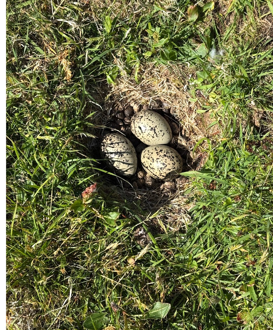
An Oystercatcher in Scots is the onomatopoeic Pleep. The Gaelic word is Gille Brighde - also the name of my favourite restaurant. Pronounced gillie bree-je, it means the guides of Bridget, because of a legend that the birds guided St Bridget to a safe harbour.
We spent most of the evening looking over the Sound of Harris and thinking - that looks a long way.

There is a ferry from Berneray, which is linked by a causeway to North Uist, to Leverburgh on Harris, and we did discuss paddling over to the ferry port and putting our kayaks on it. But we got the forecast, and we knew it was going to be better the following day. So, we made camp.
Day Three: The Sound of seals

We decided to go for it and cross the Sound of Harris. We were up early, about six am - but it takes a couple of hours to make breakfast, strike camp, carry your belongings over the rocks and repack them into the kayaks.
I was feeling pretty trepidatious. It is no small thing to cross the Sound. It is a long way and there was quite a swell. And once you are committed, it may not be possible to turn back.
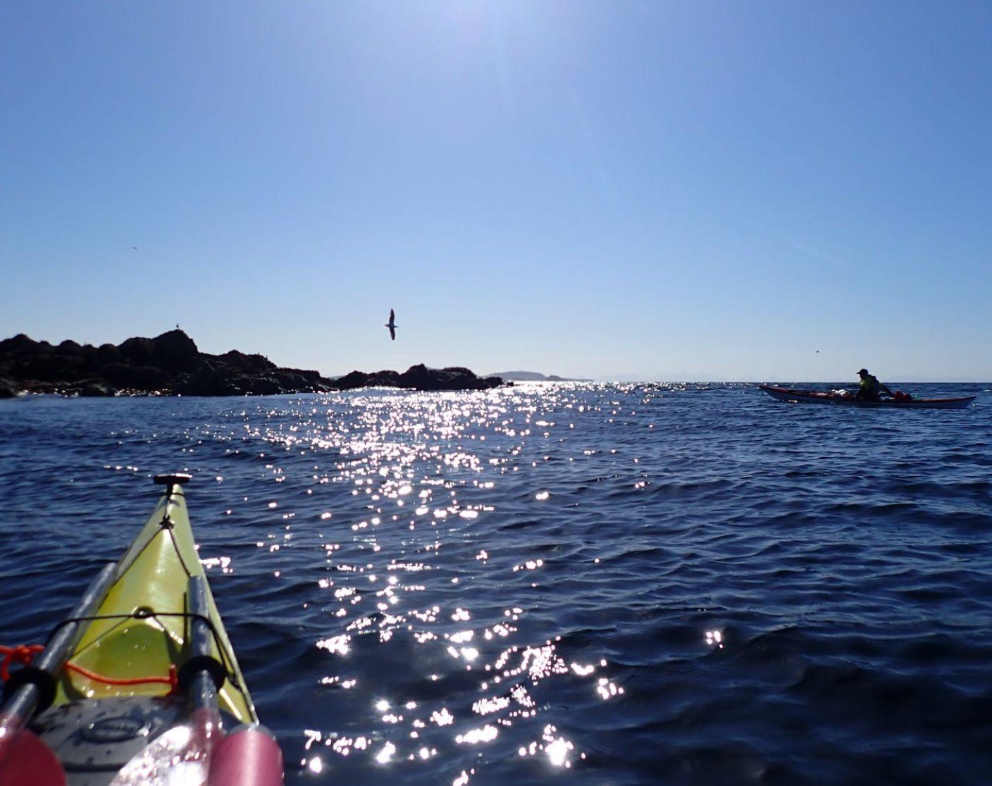
So we set off feeling this is scary, scary - and then - it was pretty crazy - but the seals were singing.

We also passed less than 50 metres from a sea eagle - amazing birds. I couldn’t get a photo because I was paddling. We were going into the wind, which is hard work but more stable.
Navigating was challenging. We were going towards what the map said were three islands - but they looked like one. You don’t want to make a mistake because you don’t want to have to retrace your steps.
The last two or three km of the crossing was tough. It was really windy and we’d been paddling for a good while. There was quite a swell and at times it was choppy - the water was what we would call confused.
Chris - the guy we met later that day - told us the water is extremely shallow in places, which is why they use specially designed boats with internal propellers that are less likely to snag on rocks. Plastic bags are now the biggest hazard - they get sucked into the intake and clog it up.
Obviously, shallow water is not so much of a problem in a kayak, but you really feel the shifts in water behaviour when there are submerged rocks - because of the way the current eddies and bends around them.
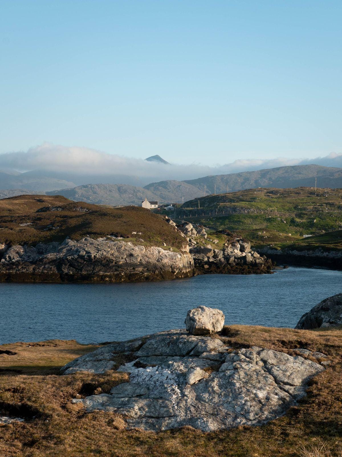
Rodel House
After the crossing, we saw the medieval church of St Clement’s appear on the headland - we were now on the isle of Harris. Rodel was once a major settlement and the capital of the island. We went into the harbour below a grand Georgian house. We needed fresh water. We hadn’t found any on Sursaigh the night before, and we'd only topped up once since leaving Lochmaddy.
We went sneaking around, probably looking a bit wild and weather-beaten, unsure if we were meant to be there. Eventually, we encountered Chris, who turned out to be the manager of the place. He welcomed us, told us the harbour was open to all seafarers and let us charge our phones, and fill our water bottles from his tap.
We talked about the restoration project and life in the Highlands and Islands generally. He eventually asked, “So, where did you come from originally?” and then, when I said “Edinburgh”, he asked what school I had been to. I turned to Paul and said: “Chris has asked me the Edinburgh Question!” But then we discovered that we had both been at the Edinburgh Academy a few of years apart - small world. Of course, our reminiscences included some difficult reflections on the recent abuse scandal that has affected the school.

We had a great conversation with Chris about the history and renovation of the building. It’s a beautiful place to approach by kayak. Rodel House dates back to 1781, built by Captain Alexander MacLeod, of the MacLeods of Harris and Dunvegan. Chris showed us round - polished wooden floors, elegant proportions - it is available to rent and it is spectacular.
By this time, it was about 3 pm, so we set off again, to make a bit more progress. We were hugging the coast, and it was very bumpy and choppy. Paul’s boat started to come apart a bit. He has a portable boat which is in three sections, and the bolts were starting to come loose.
We found a sheltered spot. He had to roll into the water and tighten all the bolts, and then get in and roll right side up. I was helping. After that, it took us a while to find somewhere we could actually land. We eventually found a place to get ashore and made camp.
Day Four: Encounters

This day was long and into the wind. We stayed close to the coast and the water was choppy.
We stopped for a lunch break on the uninhabited island of Stockinish and we had one of several close encounters with an otter on the way in. After that, we were out of drinking water again. We went into the natural harbour of a beautiful house on the east side of the Cluer peninsula that is only accessible by sea. There was nobody there. We walked up the stream behind it and refilled our bottles.

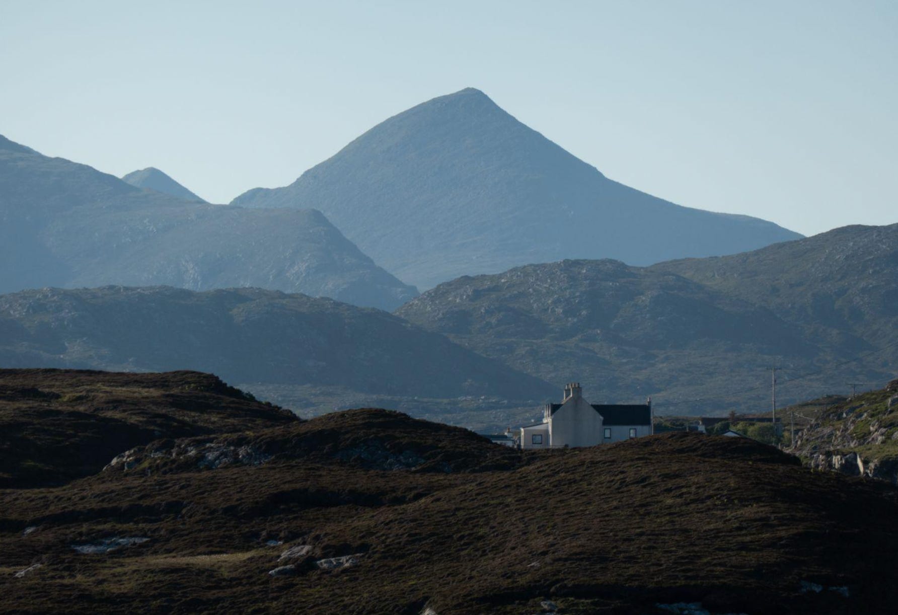
Harris is home to the mountain of An Cliseam (Pronounced Clisham, Gaelic for ‘The Horseshoe’). This is the only one of Scotland’s 222 Corbetts - peaks between 2,500 and 3,000 feet - in the Western Isles.
Eventually, we made camp on the island of Scalpay. We saw a woman walking a few hundred metres away, the second person we had seen in days. We waved to each other.
Day Five: Crossing to Lewis
There is no map for this day - I forgot to turn my smartwatch on. We came to Loch Seaforth, which marks the boundary between Harris and Lewis. We were thinking of going up into the loch. The previous day had been 24 km and this was a long one too - so you have to think about whether you’re becoming over-tired.
I would have liked to camp somewhere on the south side of the bay leading into Loch Seaforth but there wasn’t any obvious place to do that. So, we committed to the 6 km open-water crossing, partly because the sea state initially seemed quite benign.
It turned out that a huge volume of water was pouring out into the sea from Loch Seaforth. This tidal flow was running against the wind, which created a very choppy couple of km right in the middle of our big crossing. We would not have wanted to run a rescue in the middle of that.
After arriving in Lewis, we eventually came to the deserted township of Bhalamus - with lots of empty houses. It was very eerie. The crofters there lived in relative comfort, and they had fine stone houses. But they were brutally cleared from their crofts in the 19th-century to make way for cattle-grazing.
I thought I had found the perfect place to camp, on a patch of green there. But when I went over, it was absolutely covered in flies, which I think was because of decaying seaweed. So we camped on the rocky shore.

Day Six: In the swim

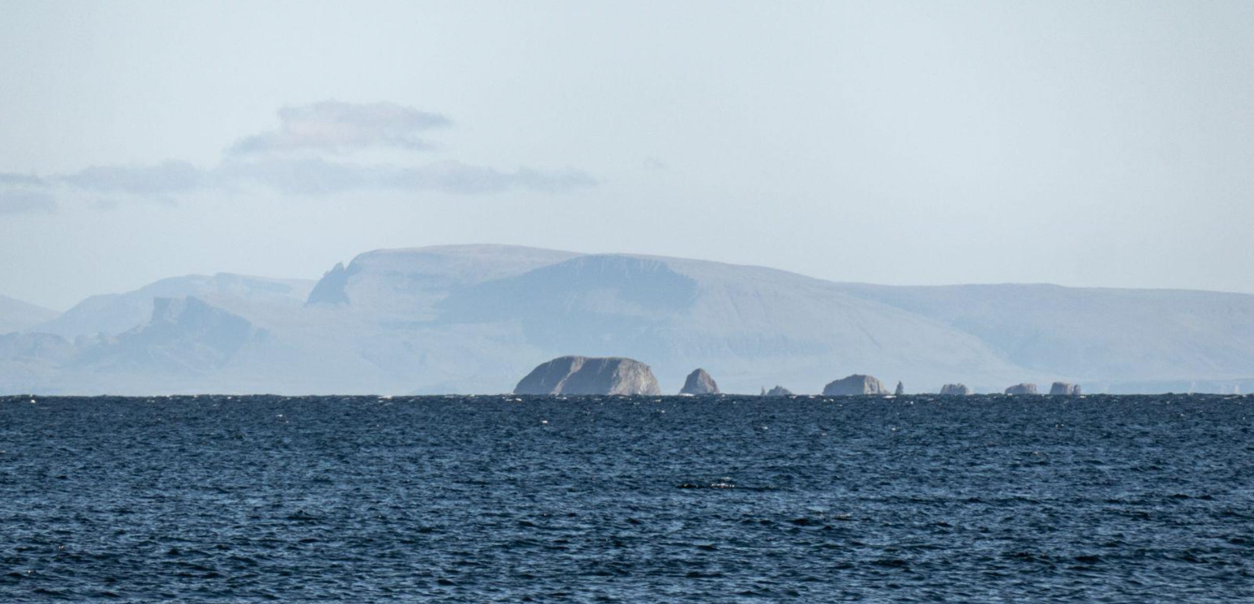
Looking out from Lewis towards the Shiant Islands, once owned by the writer Compton Mackenzie
This was another long day, many hours padding into the wind. We could see that the wind was about to change and we weren’t clear what effect that would have. The weather was also due to become unsettled so we were keen to press on.
There was an incident when Paul dropped his paddle. I lent him my spare and then he set off frantically looking for it. I started looking too, but the small waves were high enough to hide a floating paddle. I thought it might help if I got up a bit higher, so I pulled my boat up onto a promontory and started peering out through my binoculars. Paul saw me and thought I was birdwatching and was cursing me. But then I spotted the lost paddle and was able to point him towards it - he realised then that I wasn’t ignoring the emergency for recreational purposes.
We saw many sea birds - here is Paul with some Arctic Terns

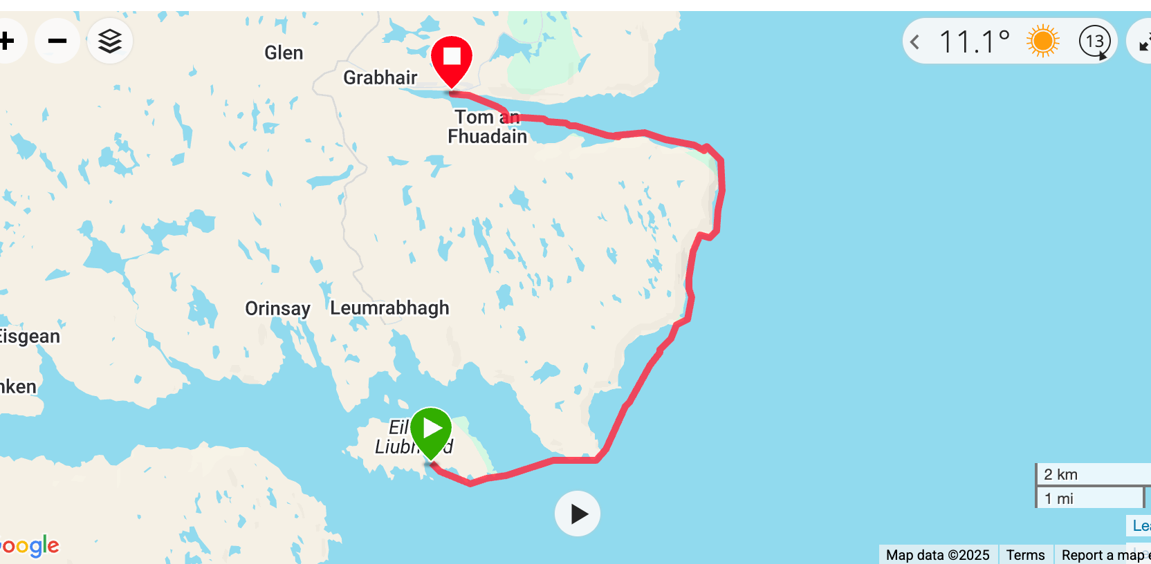
We camped on Eilean Lubhaird. Paul went for a swim as he did every day.

Day Seven: Returning
We had been going solidly against the wind. That was the way the swell had been moving for days. But as the wind came round into another direction overnight, we then got swell coming from two directions 90 degrees apart - not a great combination.
So the conditions became quite difficult and, combining that with the successive jagged headlands that we needed to go round, getting all the way to Stornoway made less and less sense. We turned inland towards Grabhair, where there is a bay and a road. We met a dedicated amateur lobster fisherman there - he had caught more over the previous year than most of us eat. Meeting him marked our return to ‘civilisation’.
Paul had got the name of a taxi van that could take the kayaks. Initially, he said he could not come until the next day. I announced that I was going to leave my kayak and hitch a lift to town. That was a unilateral decision on my part, which Paul found slightly annoying, after a week of collaboration. He said he would camp and stay with the boats.
Eventually, the taxi did collect us and the kayaks. We had an interesting chat with the driver, who told us about the challenge of maintaining the Gaelic language - his older kids would speak it at home but not the younger ones. We stayed in a hotel. I booked a twin room - Paul ended up wedging himself into the bathroom and taking his emergency sleeping pill because of my snoring. That was fine until I wanted to use the loo and had to wake him up - not ideal. Ironically, this was probably the most disturbed night of the whole trip.
The trip was challenging but it was a great experience and I was glad to share it with my old friend of 40 years.

Rob’s photos are available to order from his website, rob-bruce.com. Prices start at £55, including postage, for aluminiums (which don’t need framing) and £65 for unframed giclee prints.
Rob is also holding a joint exhibition with painter Ann Campbell at Edinburgh’s Dundas St Gallery from April 23-29, 2026.
Wow, what a read and what a fantastic journey you two. I take my hat off to you both.
Gosh, Scotland is so lovely, great adventure!